
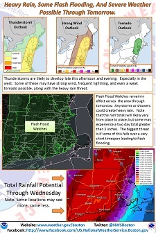
Left: NWS forecast issued this morning shows likely 2.5-4″ of rain for today and tomorrow. But emergency weather officials warn of other dangers with erratic weather patterns. (Click here to see the full size map on Facebook)
Southborough Emergency Management asked me to share a weather alert for our area. As you are probably aware, erratic storm fronts throughout the country are also threatening our region.
The forecast includes a possible 2-6″. The most recent National Weather Service maps posted to Facebook show a likelihood of 2.5-4″ of rain in our area for today and tomorrow. And they warn of flash flood potential. (So, make sure your sump pumps are in order!)
There is also a low probability of hail and even a weak tornado. Though, from the NWS map, it looks to me like Southborough is outside of even that 2% probability area. We also seem to be on the edge of the “slight” probability of thunderstorms.
But as SEM warns, the weather is unpredictable. So be on alert for changes in the sky and listen for emergency warnings.
From SEM:
As you can surely tell if you have been outside – conditions are ripe for severe weather. Add to the mix a strong cold front moving in from the west and conditions will be ideal for severe weather. . . The extent and severity of weather is difficult to predict as most activity will be sporadic.
The National Weather Service (NWS) is looking at a potential (in order of likelihood) of 2-4″ rain (isolated 6″), straight line winds, hail, downbursts and tornados.
Like all predicted severe weather the best action is to closely monitor the sky and weather forecast updates/warnings.
SEMA remains at a Level 1: (Monitoring) and will send out updates as necessary.
SEM also shared a more detailed warning from their regional emergency weather specialist, Jim Arnold. While today and tomorrow’s forecast are rough, he offers hope for a fine weekend:
Our area of Massachusetts is looking at a pretty interesting 36 hours. The National Weather Service has continued the Flash Flood Watch for all of Southern New England except the Cape and Islands through Wednesday afternoon and is expecting rainfall totals of from 2 to 4 inches with some local amounts up to 6 inches where the heavier showers and thunderstorms occur. In addition to being primed to deliver very heavy rain, atmospheric dynamics are set to trigger another round or two of severe thunderstorms across Massachusetts and all of Southern New England today and tonight. The Storm Prediction Center has placed Central Massachusetts in an area that has a 5 percent chance of hail and a 15 percent chance of wind reaching severe limits. The SPC has also identified an area with a 2 percent chance of a tornado that includes Central Massachusetts. As I have said many times, that is a low probability, but it is not zero and needs to be monitored closely. In their forecast discussion, the National Weather Service also mentions the possibility of a weak tornado today and tonight.
Here is a link to their discussion. . .
And here is a link to the Storm Prediction Center convective outlook for today. . .
Our weather should begin to improve by late tomorrow afternoon and Thursday, Friday and much of Saturday promise to be ideal vacation weather, with low humidity and temperatures around 80.
Keep up to date on the latest forecasts from radio, TV and internet sources while the severe weather threat is active.
