
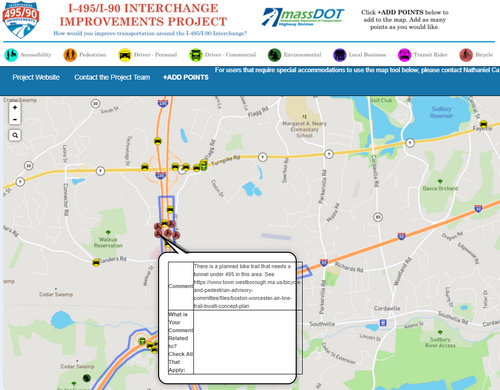
Above: The state’s request for comments on needed road improvements includes elements that could allow a bike path to cross through Town (image cropped from MassDOT interactive project map)
In October, I shared that the state was collecting feedback on a major commuting hub in our area. A reader’s comment alerted me today to an element I missed at the time. It’s an opportunity for bicyclists to weigh in on a potential big change.
As I posted last fall, the Mass Department of Transportation asked for comments on the Route 495/90 Interchange. Because of it’s proximity to the Route 9/495 Interchange, they were also seeking comments on needed improvements there and nearby.
Based on concerns many residents have voiced about the section of Route 9 West leading to 495 in the past, I focused on roads, drivers and safety complaints.
But, as a reader pointed out, the Interactive Map for commenting also asks for feedback on potential bike paths.
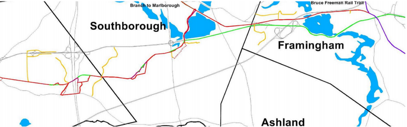 The plan for the Boston Worcester Airline Trail (BWALT)* would connect bike paths through Framingham, Southborough and Westborough. (See image right.)
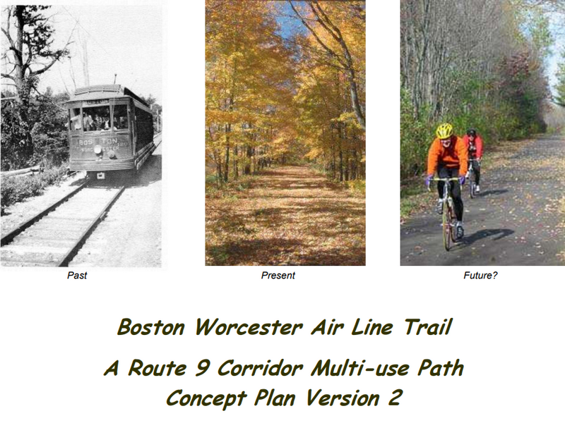
As part of that, a culvert tunnel is proposed to allow the bike trail to pass under Route 495. The Town of Westborough’s website shares the bike path proposal for “Boston Worcester Air Line Trail: A Route 9 Corridor Multi-use Path”.
 The proposal summary includes this description:
A significant portion of the former Boston and Worcester Air Line Trolley’s private right of way that runs along Route 9 is still intact. It is believed that much of the rail line route extending from about half a mile east of Worcester to White’s Corner in eastern Southborough could be fairly readily converted to a multi-use trail. Further adding bike facilities in the Lakeway District of Shrewsbury could extend the western end of the trail to the bike lanes on the Kenneth Burns Bridge over Lake Quinsigamond to create a link into Worcester. In the same vein, to the east, developing a rail with trail along the CSX branch line would connect from Introduction Southborough to the planned Bruce Freeman Trail in Framingham.
You can see the full proposal here.
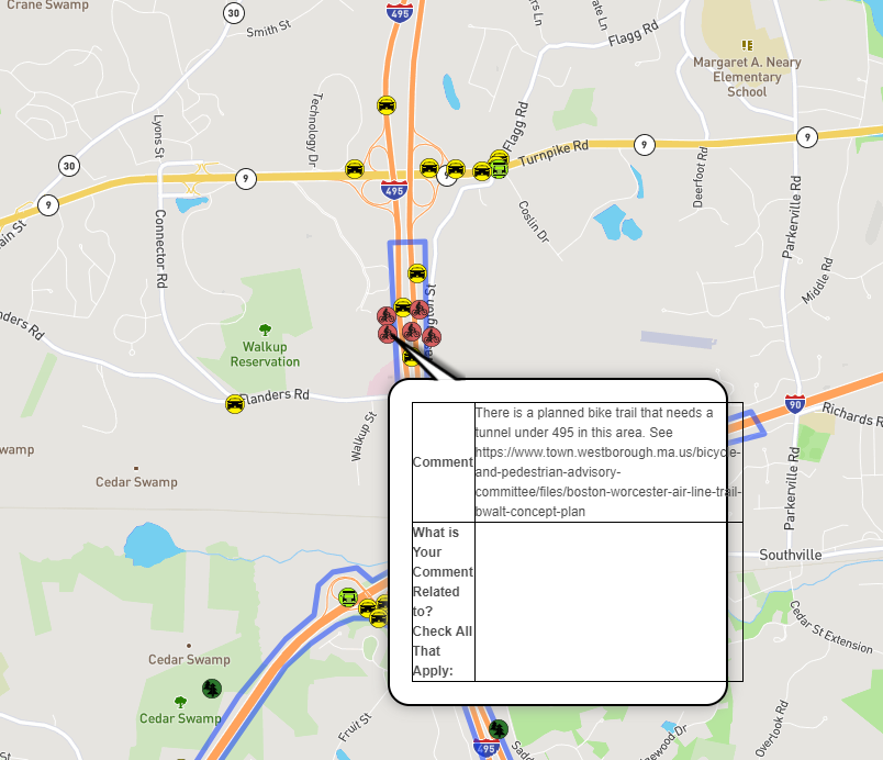
To comment to the state, you need to visit the state’s project website. I’ve included an image right highlighting which bike icon to click on to find the appropriate field to comment in. (The tunnel would be in Westborough, but facilitate linking a trail that would continue through Southborough.)
To read my original story on the road interchange project, click here.
*Updated (1/31/18 7:56 am): Commenter Don Burn, who worked on the proposal, informed me that I incorrectly labeled the trail as the Bruce Freeman Rail Trail. Apparently, I misread the trail map. Now I understand that the Southborough section is part of the BWALT trail that would connect to the Bruce Freeman Rail Trail, not be considered part of it.

What a great idea!! but why is easements needed ? I always thought it was state land, IT really would be nice to walk/bike on it when it is completed, seeing the roads in southborough are not walk/ bike friendly it would be a safe place to use for all ages.
Hope it will be a reality . but like everything else, it seems to take years and years just to cut though the red tape.
Section 4.2.4 is going through our garden.
Best alternative is to use Mt. Vickery instead. Nor am I listed as an abutter.
Which is interesting.
A long time ago around 1974 there was rumor of the state opening up bike trails around the MDC DCR property “reservoirs” along with boating etc.
I guess the results haven’t come back yet.
I hope you will be commenting to the state on that. I assume by abutter, you really mean property owner that easement is needed from – because that is what is listed in the doc. (I couldn’t find an abutter list.)
When I looked at the proposal yesterday, I didn’t pay close enough attention. It looked like the focus was using old railways and trails. I didn’t notice how many private properties the trail passed through. It didn’t occur to me that areas of the trail might pass through someone’s property who hadn’t agreed to the idea.
It certainly looks like the trail is drawn to move through your properties south of 146 Cordaville. And, as you point out, your properties aren’t included in the list of easements there.
I see there is an alternate route – the one you point to as best alternative. But your comment makes me wonder about the other properties the trail passes through and how many of those owners don’t know about it.
Did you receive any communication/notice about the proposal?
Could 4.2.3 and 4.2.4 go north around the solar farm? It wouldn’t be on an old rail right of way, but it’s MWRA land. OTOH, the MWRA is pretty tight with permissions.
It could go around to the north, but it would probably cost about $500,000 for a short piece of trail to keep the gradient within the guidelines required for multi-use trails. As I stated elsewhere this is a “concept plan”, i.e. this is an early attempt to show that the trail can be built.
Hello Beth:
This is the first time that I’m seeing the map though I had read about via your previous post. Very good question about other abutters. We never received any notice.
I am the primary author of the bike trail plan. Yes it does require a lot of easements from private landowners, in Westborough we have been able to work with the land owners and will soon have a route from the MBTA station to the area with the tunnel secured.
We realize that not all landowners will want the trail, and in many cases there may be alterative routings that can be used. Rail trails take a long time to build, and much of this is due to the process of working with landowners to find a way for the trail and the needs of the property owners to coexist.
FYI – I believe the link provided to comment on the plans (“project website” hyperlink) brings you to a map as opposed to the project itself. I didn’t see how to comment on it.
When you click on icons in the map, a field pops up (like the one pictured in the story) allowing you to post a comment on that specific element.
A few corrections, this is not the Bruce Freeman Rail Trail that trail goes from Framingham to Lowell. This is a concept plan for the Boston Worcester Airline Trail (BWALT). This is not a state project, it is a project that is being considered or undertaken by the communities it goes through. Commenting on the WikiMap will not cause the trail to be built or stopped in Southborough since MassDOT is not involved with building the trail.
Westborough is building its part and is getting interest from businesses moving in because of the potential rail trail. Southborough is the community that has done the least.
I asked people to comment on tunnel since Westborough hopes to have the tunnel and it will lead to the Dell / EMC campus on the border of Westborough and Southborough. If at some point Southborough becomes interested in a trail this is an important linkage.
Thank you for clarifying. I updated the post.
The Southborough Police – well, one officer – threatens arrest for trespassing on the CSX right of way after 4.3.1. I would think that could be worked out, especially since many people, including me, have trespassed there, to judge by the litter, discarded underwear, and footprints.
It appears as if the part of the trail proposed from Framingham center to White Bagley Road is on an active CSX railroad line. I am all for creating bike trails as I find it extremely challenging trying not to be the target of distracted drivers when I bike, however, I would think CSX would be very concerned about bikes and walkers being allowed to use their active right-of-way.
Kelly, it is against the law to trespass on railroad property: M G L c 160 s218. Granted, the train on this line travels very slowly, but on other lines, especially the T lines, trains travel at 60 and 70 MPH and can sneak right up on people, especially whey they have ear buds in, etc. In fact, I believe we have had a few people killed here in town walking on the railroad tracks.
Yes, it is an active line, although there’s plenty of space to be there safely.
CSX will be the most challenging part of this effort. Bottom line is it will require a coordinated effort from a number of communities that have trail efforts that need easements from CSX working together with state legislators to probably get this going. One of the reasons I would like to see Southborough get interested, is that this needs to be a coalition of groups.
I just read Don Burn’s post above, I am shocked to hear that southboro has done the least for the project, my question is WHY? I thought that’s why we pay a town Planner ?
correct me if I’m wrong , Is there state grants allocated for this type of trail? and if they are why are they not being applied for? seems odd that we the tax payer just found out about this, has the town house been keeping this news to themselves again
Arborist,
The last 3 planners in Southborough, plus the Recreation Department and the Conservation Commission have people who are aware of the effort. I believe it is assigned to the Southborough trails committee. Having worked with communities on trails over the years, I would recommend that Southborough consider creating a Bicycle and Pedestrian Advisory Committee like Framingham and Westborough have to drive efforts like this.
You Hit the nail on the head Don (last 3 planners) When things got hot in town they left for a cooler place, so not too much got planned, That’s why southboro is in the mess that it’s in now. what were they doing behind their desk? you be the judge.
It would truly be a shame if southboro turns it’s it back to a chance to make this rails to trails a reality
Question about CSX rail line.
. Mention is made of the “CSX branch line” in Southborough, as a possible trail. Does that mean the line from Framngham Center, passing thru Fayville, then thru Southborough village center, on its way west, (to Clinton, I believe).?
If so , then I think it could potentially be worked out, because (I believe) that right of way once had TWO tracks, whereas it now has ONE track ….but this needs checking … If so, there should presumbly be space available in the rail right-of-way for a parallel hiking/bike trail … But it would need a fence to divide off the active rail line.
Any answers? Is this possibly linked to the Westborough trail. ?
Yes the CSX branch line is part of the plan for the BWALT trail. The branch was until the 1960’s double track through Framingham and Southborough to support commuter trains to Marlborough. The BWALT trail wants to develop that line both to Marlborough, using the on road bike facilities being put in on Route 85 in Marlborough. Also, the BWALT wants to split off from the rail line at White Bagley Road and follow the road on DCR property down to Route 9, where south of there the trolley line is mainly intact to Westborough.
Note: Westborough is looking to host a walk on its part of the trail in May. We are exploring having walks in towns to the west of Westborough (sorry but all the land is private right now in Southborough except for the short piece on DCR land). We have also offered to do talks about the trail for a town if they will host it.
For people who want to understand the BWALT multi-use trail, there is a walk on May 6th at 1:30PM starting at 2000 West Park Drive in Westborough. This will be a 2.5 mile walk with a car shuttle explaining what Westborough is doing along the old trolley right of way. The right of way is identical in Southborough, and would give people a good idea of the possibilities and challenges of the piece of trail from Crystal Pond Road to the intersection of Route 9 and White Bagley Road.