
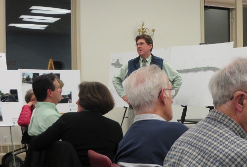
Above: The town’s engineering consultant fielding residents’ questions on the Main Street reconstruction plans at DPW’s public meeting Wednesday night.
Before I recap the DPW meeting from Wednesday night – here are some important related details and meetings to note.
- A meeting to explain the Main Street Review Committee proposed by David Parry’s Citizen Petition Warrant Article will be held on Wednesday, April 9, 7:00 pm at the Library.
- The State Public Hearing has been moved to June 16, 2014.
- Residents that want to weigh in on whether the project should proceed while seeking state funds or come to a halt, should share their views with the Board of Selectmen. You can email them at selectmen@southboroughma.com. (If you want to be taken seriously, I assume you should provide your name and address.)
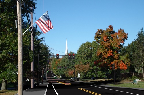
- New renderings of the project “before and after” have been shared by DPW (One example below, click here to see the rest)
On Wednesday night, the Department of Public Works held a meeting to explain the Main Street reconstruction project plans.
The room was packed with residents, many with questions and comments. Most of the commenters wanted to convey their displeasure with the plan. Some wanted to know how to improve it, while others wanted to stop it all together.
Residents had a chance to look at a large scale printout of the plan and new before and after renderings. Next, the town’s consultant, Brian Brosnan of VHB, pointed out changes made under the current plan, reasoning, and choices still to be made. Then he fielded questions.
Concerns shared revolved around safety issues, a fear of drawing more commuters and a perceived change to the character of the road.
Several residents stated that the plan, and especially the 4 left turn lanes at the intersection, would turn the road into a highway. They said the state wanted this to become a commuting corridor for people avoiding route 9 traffic. They also believed that it would increase the backup of traffic on Route 30 heading towards the reservoir.
Brosnan defended the intersection as justified for safety and ease of traffic flow based on their traffic projections for the area. He said it was designed in mind with 20 years of continuing development in Southborough. But his firm hasn’t studied traffic further up the road.
Main Street resident Karen Connell claimed to have come to the meeting with an open mind. But based on what she saw, she was certain, “This is not an appropriate plan for Southborough.”
Connell said that the traffic issue further down Main Street would effect all the surrounding streets, including School Street, Newton Street and Latisquama:
When there is a backlog. . . what do people do? They look for ways out. This is a highway, and you’re marrying a highway into a small village. . .
Former DPW Chief John Boland questioned the perceived issues. He asked the room why commuters would take the road as a highway if there was a bigger traffic problem up the road.
DPW Director Karen Galligan said that the intersection was originally designed with two left turn lanes. Additional lanes were added after that plan was questioned in past public meetings.
Residents also worried that the plan would ruin the historical character of Main Street. DPW Director Karen Galligan said that many of the details (the design of sidewalks, trees, and crosswalks, etc.) can still be resolved in the remaining 75% plan design period.
Resident, David Monroe, questioned the crowd’s concern for the district’s “historical nature”. He spoke about seeing “constant change” in the area of the Route 30 & 85 intersection over 56 years:
If we can improve that area traffic-wise to the benefit of everyone, there is no historical significance that’s going to be lost or impacted.
According to former Selectman David Parry, the only property owner of on the west side of Main Street that wants the drainage problems fixed is Fay School. He said they can pay for their own fix.
Main Street residents, Michael and Jane Jackson, said they welcome the ducks who come to their wet yard. They questioned the need for the project, but also apologized for not having gotten involved when the town sought community input on the project years ago.
Parry pointed to the sections of the plan, dismissing some as completely unnecessary and others as disastrous. He called the plan a classic example of how the state wastes money. The room applauded his exclamation:
Can you think of a more wasteful way to spend 6 million bucks!? It’s supposedly free, but we don’t want it.
There was some confusion in the room over answering residents asking VHB and selectmen, “How do we stop it?”
Yesterday, Karen Galligan told me that the Board of Selectmen are the commissioners of the road. While the DPW will take input on changes to the plans, the BOS will be the ones to determine if the project goes forward or halts.
The bottom line appears to be that Selectmen still need to get a better understanding of how the community feels as a whole. (Thus, as I said above, you can send your opinion to selectmen@southboroughma.com.)
There was a lot more said than I can recap. To watch the meeting recorded by Southborough Access Media, click here.
At the Annual Town Meeting on April 16-17, Parry will be asking voters to support his initiative to form and fund a committee to review the project. The goal is to present a choice the following year for the town to vote on.
Based on comments at a recent BOS meeting, the board may seek to amend the article at Town Meeting to have a committee that reports to them.
Updated (4/4/14 3:22 pm) – Apparently, April 9th is a Wednesday. Oops.

the day of the meeting on Mr. Parry’s articles is Wednesday at the Library starting at 7.
Not Tuesday. Please make a correction.
Thanks for catching. (I knew it was the 9th – just was sure the 9th was Tuesday.)
Three cheers for David Monroe.
Another date to keep in mind: April 23rd when town officials hear the proposals of the traffic consultant for Park Central. As I’ve said before, if you are worried about traffic along Main Street and at its intersection with Rte. 85, then consider the possibility that traffic heading east from the 180-unit Park Center would be routed up Flagg Road to Main St and down 85 to get to Rte. 9 east. Using Flagg Road is terrible enough but then consider adding more cars crossing or turning onto 85 in the morning! Check later news for the location of this traffic meeting.
From reading the comments here I admit this project sounded like it might have problems. But after looking around, seeing the renderings and the flags posted at the intersection, and seeing the walkthrough, I’m kind of confused as to why there are so many complaints.
What is the big deal about? Seems like we’re taking an old run down intersection, cleaning it up, adding nicer sidewalks, a few turning lanes, etc. It looks GREAT to me, and I’d love to see the central intersection of our town upgraded to something new and nice looking, rather than the cramped and crumbling area it is now.
I agree with the intersection needing work, but I don’t think the marked up pictures do justice to the scope of this project. I also noticed the there is no markup showing the changes when you head north on 85 next to the Community House. The townspeople need to look at the intersection and understand that there will be all pavement in between the markers. It looks like a lot of pavement to me and I don’t think it fits our town.
To clarify – by “all pavement” you are including the sidewalks. I understand what you mean, since there will be no grass strip. I just don’t other people to think that you mean all road, plus additional space for sidewalks.
To clarify the statement from DPW Chief Karen Galligan, the Board of Selectmen cannot “determine” if this project goes forward, at least not without a 2/3 vote of some future Town Meeting.
The project, as currently defined, requires the expansion of the road. That requires the Town to acquire permanent easements at multiple locations, for example to expand the intersection of Rt 85 and Rt 30. The State considers the highway enlargement essential to its support for the project. According to Chapter 40 Section 14 of Mass General Law, easements can only be acquired subsequent to a 2/3 affirmative vote of Town Meeting. The law requiring a Town Meeting 2/3 vote in advance of any acquisition of an easement applies equally to purchases or taking by eminent domain.
At the Wednesday meeting it was made clear by the speaker that it is the Town that must obtain the easements. The State won’t do it. I have verified this on the State DOT website as their general policy for projects initiated by a municipality and it shows this as the condition attached to this particular project in its online project database.
The need for a 2/3 vote of some future Town Meeting means that the warrant article on this year’s Town Meeting to create a committee, appointed by the Moderator, to consider whether this project is in the best interest of the Town, and make a report to Town Meeting, is directly germane to Town Meeting’s need to vote in the future. In addition it is potentially helpful to the Board of Selectmen as an independent voice assisting a decision about what to do.
Apart from the necessary Town Meeting vote to obtain easements, the State is going to hold a hearing in Southborough, the so-called 25% hearing, to hear from residents directly about whether they support the plan or not. If residents turn out to that meeting to say they don’t want it, the State will draw its own conclusions about whether to proceed or not.
There was a tone of frustration occasionally in the Wednesday meeting among the Main Street residents about what they imagined to be their inability to change this plan. In fact they have a powerful voice. Both legally and practically, the voters have enormous direct say over whether this goes forward in its currently-proposed form. Of course, it is still a good idea for citizens to provide feedback on the project to the DPW and the Board of Selectmen as they are the people immediately responsible for day to day management.
As Southborough residents grapple with how appropriate the Main Street renovation plan is for our town, one issue they should keep in mind is safety from a bicyclist’s perspective. As an avid cyclist myself, I feel fortunate to live in a town which has been able to preserve a lot of its rural character. While Southborough offers many miles of cyclist-friendly, less-traveled back roads, often the best way to access these requires cycling through at least some portion of Main Street. I know from personal experience that cycling on virtually any section of Main Street can be a delicate, dangerous balancing act of avoiding aging, uneven pavement and vying with motorists for a spare foot of travel space.
I’ve had a chance to look at the DPW’s renditions, and based on these, see a future Main Street which appears to address several safety issues at once without reducing Southborough’s rural feel. In those renditions I saw a small, but crucial, margin of shoulder that would go far to help insure a safer coexistence between motorists and cyclists. When the definition of “rural character” means tolerating an out-dated, deteriorating road which puts all of its users at risk, it seems that we should at least re-examine the definition. And if cyclists felt less in peril traveling Main Street, they might also feel more inclined to consider riding a bicycle in place of a car trip, potentially reducing motor traffic in warmer months. In short, the town’s Main Street project appears to be one which goes a long way to addressing safety issues for motorists, cyclists and pedestrians alike.
Sam, I don’t think anybody would agree with your definition of “rural character”. Let’s be fair.
In all respect to Tim, I don’t think it’s fair to assert that no one would agree with what anyone else says about almost anything (namely saying that likely no one would agree with Sam). Say what you think but it’s a tough one to suggest what others may or may not think. In fact, a lot of the time thinking we know others’ thoughts leads to some real surprises!
Donna, for me, “rural character” does NOT mean “tolerating an out-dated, deteriorating road which puts all of its users at risk.” I think Tim’s pretty safe with his contention, your comments towards tolerance notwithstanding.
I tried not to respond but must say that none of us can claim to say what other people in town are saying or believe. Yes there are those of us who respond on this blog or who make comments at meetings, but likely we each travel in different circles much of the time and so our vision is limited. Easiest example: Have you heard conversations at the Senior Center lately? I haven’t–but I do run into Southborough people at my health club and in the supermarket (most often in Westboro). Not sure those people have made their views known to others or that those views are shared around town. Maybe…how can any of us make statements for others based on our own assumptions? I just don’t like the idea of making sweeping statements about other people’s views. Plenty of times I went to Town Meeting SURE I knew enough to know what the vote would be–but I wasn’t even close!
With the library, community house, and three schools around the intersection, I hope sidewalk saftey takes more of a priority than the 4 turn lanes. I was origninally swayed by the wonderful renditions, but am begininning to realize that the more ‘efficient’ that intersection becomes, the more traffic and dangerous it could become. Including downtown, old post office and Fay school crossings which tend to have most pedestrians looking to cross Main Street. They recently installed that light for the St Marks students to cross the street from dorms to campus, could something like that be used to ease or deter speeding at a point on Main Street. Does anyone know how that light came about as it seems to make a lot of sense on a portion of road that has more visibility (less curves/blind spots)?
That St. Mark’s crossing light has been there longer than you may realize, almost 20 years I would say. It came about because two town residents (my wife one of them) who were mothers of St. Mark’s day students worked with the then Police Chief Colleary, I believe, with the encouragement of the school, to get it installed. I agree with you that traffic calming, not traffic expediting, is needed in front of Fay. Apparently, however, there may be an obstacle to a crossing light in the form of a rule about how close lights can be to one another, although I’m not sure about the rule.
Also a note about my earlier post. It has been pointed out to me that the controlling law for Town acquisition of rights of way for roads in particular is Chapter 82 Sections 21-24 as regards approval by Town Meeting, not the statute I cited which is about general purposes. I think that when all is said and done and appropriations must be made for this purpose, the effect is the same, and it certainly has been our practice here that all land acquisitions or roadway acquisitions need a 2/3 vote of Town Meeting. In the end, Town Counsel will need to offer an opinion about process.
Now that you mention it, I do recall that St. Marks light being there…just never used, right? The crossing by Fay is a disaster waiting to happen; especially when you consider the solar glare (east/west), the blind curves, and its undulating topography (won’t mention the Turkey crossing). Can’t imagine there are any rules about lights being too close together especially when you consider the proximity of the latest train station light.
Until recently, I supported moving forward with a review under the supervision of the BOS based on the project being managed under the BOS’s sole authority. This opinion was based on Town Meeting not having any authority with respect to road policy which is the exclusive right of the BOS.
While Town Meeting has no authority with respect to road policy it does have the final say with respect to the acquisition of real property and easements. After seeing the presentation of the 25% plan and understanding the extensive requirement for easements it is clear that authorization of Town Meeting is required to acquire these rights. My reading suggests that a majority vote is required to acquire the easements and that a 2/3 vote is required to appropriate the funds to secure these easements either by negotiation or taking. The current plan as proposed clearly requires legislative action by Town Meeting and as such, the appointment of a committee to advise Town Meeting regarding this issue is a reasonable thing to do.
The apparent requirement to achieve a 2/3 majority at Town Meeting is a high hurdle. The political reality is that a modest group of motivated citizens can probably muster the required votes to cause this to fail. As a result, I believe that we should resolve this issue promptly and either secure the easements or decide they cannot be secured before we spend significant sums in further design activities.
I remain very interested in finding a way to have the State fund the road work but I am more interested in not repeating our experience with the proposed senior center building where we paid for a design we could not use.
In my experience, these types of “overlaid photographs” are not the same as measured perspectives. They are used to give a visual impression but are not necessarily dimensionally accurate.
in the case when you compare these renderings to the plan, they don’t seem to reflect the roadway and sidewalk locations on the plan. An example is the area showing the roadway between the common and the funeral parlor (the second set of renderings). The plan indicates that the inner edge of the sidewalk now, will be very near the outer edge of the sidewalk once the road is widened. The rendering does not reflect this. Just look at the location of the “jct 85” sign. Also, on the same rendering, what is the deal with the left-most power pole? The rendering makes it look like the wall is actually moved several feet to the south, into the current roadway.
Beth, could you ask if the renderings reflect the accurate proposed widths of the new roadways?
I got a response from DPW head Karen Galligan, below:
Perspectives are tough to measure, so I can’t say it is absolutely correct or wrong. The renderings were meant to be spatially and dimensionally correct. However, I can see what the poster means about the front of the sidewalk on the Middle Road view, it does look like it starts too far from the existing back of sidewalk. I checked the plans and the proposed front of curb is about 2.5 feet from the current back of sidewalk in that location, not at the current back of sidewalk as the poster says, but also not at the front of current sidewalk, where it looks like it might be in the rendering. The location of the back of the sidewalk in the rendering looks correct. The bump out of the sidewalk looks correct also. I just think the parking indent might need to be deeper, basically the sidewalk looks a little too wide.
I will send the comment to the engineer to check the rendering. However, I don’t understand the issue with the utility poles. Those look correct. The utility companies agreed to increase the distance between poles and there are only 3 poles in the proposed plan instead of 4, and they seem like they are in the right spot, none looked like they moved south to me.
Thanks for the inquiry. I’ll get back to you as soon as I hear from VHB.
If you look at the power poles, they are in the same location in both the “before” and “after.” But in the “after” the left most power pole appears to have been cropped and grass added in the space between the pole and the stone wall, giving the appearance that the WALL has been moved south into the roadway.
Thank you for the response and for looking into the matter. I look forward to what VHB has to say.
After reading these comments and the hurdles that must be overcome to start, I am thinking some charity in town aught to run a contest called: Guess the Start Date of the Main Street Project. Ten bucks per guess, half the proceeds go to the charity. At least some people can have a little fun with some good cause getting some dollars.
If this contest starts, I’ll take June 17, 2019.