
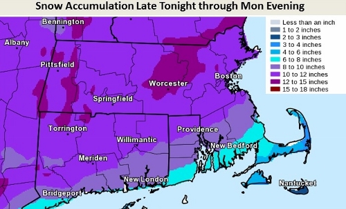
Above: The latest area snowfall prediction from the U.S. National Weather Service on Facebook
You thought you had your fill of snow after last week’s storm, blizzard, and flurry. But there’s more to come.
I held off on sharing National Weather Service’s forecast yesterday to see what new data would come in. Since then, they’ve upped their prediction to be closer to what Southborough Emergency Management’s expert projects.
In Southborough, we are likely to get more than 10″ of snow between midnight tonight and Monday midnight. And we could get up to 15-16″. (There is also a possibility of 20″ of snowfall in isolated areas of our region. On the other hand, we could get as “little” as 9″.)
The good news: We’re just north of the area NWS expects to have periods of sleet and freezing rain. SEMA predicts snow will again be light and powdery in our area.
The bad news: NWS maps us in an area of high probability for 1-2 inches per hour of snowfall for the morning commute.
Here’s the forecast for NWS for Southborough:
- Tonight: Snow, mainly after 2am. Low around 9. Northwest wind around 6 mph becoming northeast after midnight. Chance of precipitation is 90%. New snow accumulation of 1 to 2 inches possible.
- Monday: Snow. The snow could be heavy at times. High near 21. Wind chill values as low as -2. Northeast wind 7 to 14 mph, with gusts as high as 24 mph. Chance of precipitation is 100%. New snow accumulation of 7 to 11 inches possible.
- Monday Night: Snow likely, mainly before midnight. Cloudy, then gradually becoming partly cloudy, with a low around 0. Wind chill values as low as -13. Northwest wind 11 to 13 mph, with gusts as high as 23 mph. Chance of precipitation is 70%. New snow accumulation of 1 to 2 inches possible.
Below is a more detailed forcast from SEMA’s weather expert, Jim Arnold:
By now I’m sure you have heard about the storm to impact central Massachusetts on Monday, and yes it’s true. A disturbance currently in the Midwest and moving east will develop a secondary center off the Delmarva coast later tomorrow. This storm will intensify and turn to the northeast, running up the coast and likely passing over or just to the west of the benchmark. While I do not expect a storm of the magnitude of our recent blizzard, this one has the potential to cause blizzard or near blizzard conditions over the southeast half of southern New England. There will be serious impacts from this storm as outlined below.
Snow: Most if not all of southern New England will be covered by a significant snowfall from this storm. It will be quite cold so the snow will again be light and fluffy. As in the last storm, there should be a snow to liquid ratio of at least 15 to 1 if not a bit higher. The latest data indicates melted precipitation equivalents of 3/4 of an inch to a bit over an inch. Doing the math at a 15 to 1 ratio argues for snowfalls of 12 to 16 inches. A general snowfall for the greater Shrewsbury area in the range of 10 to 15 inches is quite likely, with a few isolated areas reporting as much as 20 inches. This would include areas on either side of the Mass Pike and the Route 495 corridor. In spite of somewhat warmer conditions, the south coast, east coast, Cape and Islands will see similar snowfall accumulations. There is some room for adjusting these totals a bit as the storm is still about 48 hours away, but right now I think these are solid numbers.
Timing: Snow should begin around midnight Sunday night will become moderate to heavy around 2:00 A.M. to 4:00 A.M. Monday and continue into the afternoon. By 2:00 P.M. to 4:00 P.M. it will begin to taper off but light snow should continue into Monday evening before it ends about 6:00 P.M. to 8:00 P.M. Some insignificant flurries could linger until about midnight.
Wind: The wind will begin to increase out of the northeast during Sunday night, but should only reach speeds of 10 to 20 mph with a few gusts approaching 35 mph to 40 mph across all areas. Since this will be a very light and powdery snow there will be considerable blowing and drifting during the storm. This will reduce visibility to near zero at times, particularly during the height of the storm. The relative lack of wind may preclude reaching true blizzard conditions over most of southern New England
Temperature: Very cold arctic air is in place now and this will moderate only a bit before the arrival of the storm. This will be a cold storm, with temperatures that will be in the 20s Sunday night will fall into the teens on Monday and to below zero values Monday night. The National Weather Service has posted a forecast that is not seen very often here for Monday night, calling for snow and a temperature of 7 degrees below zero. It is attached below. Tuesday morning’s temperature will threaten the all time record for the date. Very cold weather will be with us after the storm, moderating a bit later in the week. Also attached below are outputs from the European model for 8 days from now, showing temperatures of 16 below zero in the greater Shrewsbury area with windchill values of 30 to 40 below zero at the same time.
Summary: This storm might be the highlight of the winter season so far if not for the recent blizzard. While not achieving the level of severity we saw a few days ago, 10 to 15 inches of snow,with isolated spots of 20 inches is by any definition a disruptive and potentially crippling storm for a short while. Travel will become dangerous if not impossible at times. Wind chill temperatures will become dangerous during Monday afternoon and evening reaching levels where frost bite/hypothermia become a threat to anyone in those conditions without proper protection. Venturing out should wait until the storm is over if possible, to avoid the possibility of getting in trouble and putting first responders at risk.
Other Concerns: Winds during the storm will be a bit stronger along the coast, the Cape and Islands, reaching velocities of 20 to 30 mph with a few gusts of 45 mph to 50 mph from the northeast. The snow in those locations will be a bit wetter and stickier than here which could lead to a few tree limbs coming down and isolated power outages, but nothing on the scale of the previous storm.
Coastal Flooding: With less wind, coastal flooding is not expected to become a serious issue. This could change should the wind ramp up more than is expected, but that does not seem likely at this time. There will, however, be some moderate beach erosion along east and northeast facing beaches during both tide cycles Monday. As the wind shifts to the northwest following the storm passage, it will increase to 25 to 30 mph with gusts to perhaps as high as 50 mph on Tuesday making west and northwest facing beaches susceptible to significant erosion.
Marine Interests: Seas will build to near 25 feet offshore making conditions difficult for the marine community. In addition, freezing spray will develop as will “ocean effect” flurries, which will reduce visibility from time to time.
Beyond This: There are at least a couple more chances for significant snows in the near term. The potential cold coming in the next 8 to 9 days also could be severe and threaten several long term temperature records.
