
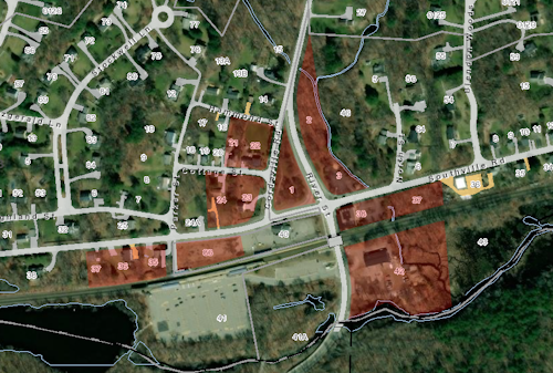
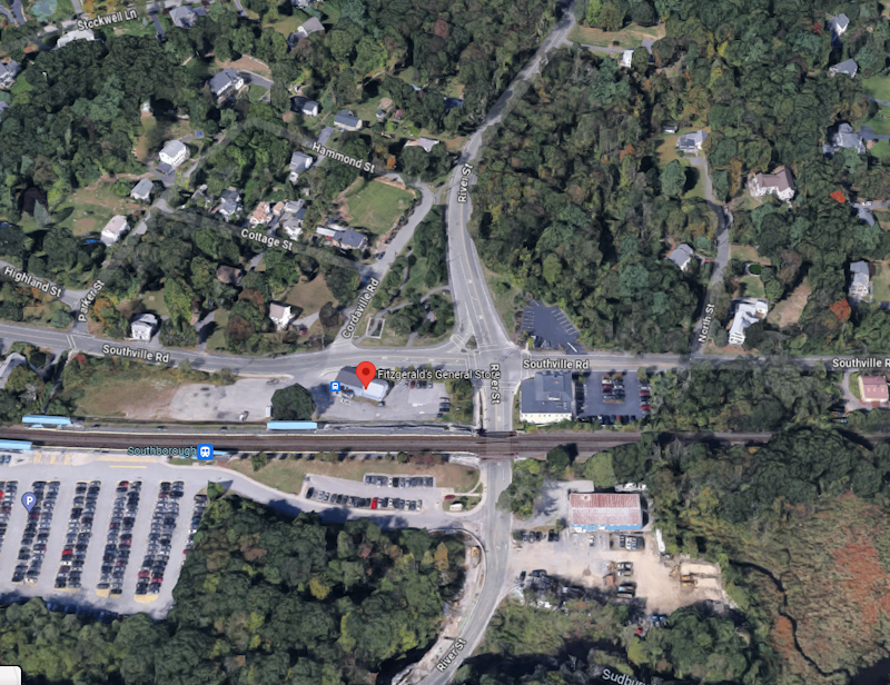
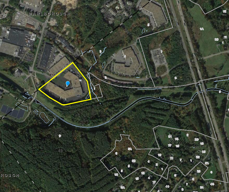
Above: Many residents within a half mile of the train station have expressed concerns about the impact MBTA Communities zoning overlays could have on their neighborhoods. This week, the Planning Board identified the parcels it is targeting in that area, and other sections of Southborough. (image from Town’s GIS Map)
The Planning Board has selected three areas of town to target for MBTA Communities zoning changes, and two more backups if they discover issues in meeting the state compliance guidelines.
The selections were previewed at their meeting on Monday night along with an explanation of next steps. Here are the highlights.
Background
For those not familiar, under state law, Southborough is identified as an MBTA Community and required to adopt zoning districts that allow up to 15 housing units per acre by right. (For more details on that, see my past coverage.)
To comply, the Planning Board submitted an action plan, committing to bringing an Article to Annual Town Meeting voters this spring. The board held public forums and mapping sessions to get input on where the overlays should be placed. This week they shared the parcels they selected.
Parcels identified for zoning overlay effort
Planning’s Business Administrator Colleen Stansfield walked the public through the parcels the board had “whittled down” to. She explained that the areas were based on public input from the mapping sessions and members working through details with help from their consultants, Bohler Engineering.
It is clear that the board sought to minimize impacts to existing residential neighborhoods. Two of the three main parcels are fully in commercially zoned areas. The other (Area 6) is mostly commercial.
“Area 6” on the southside
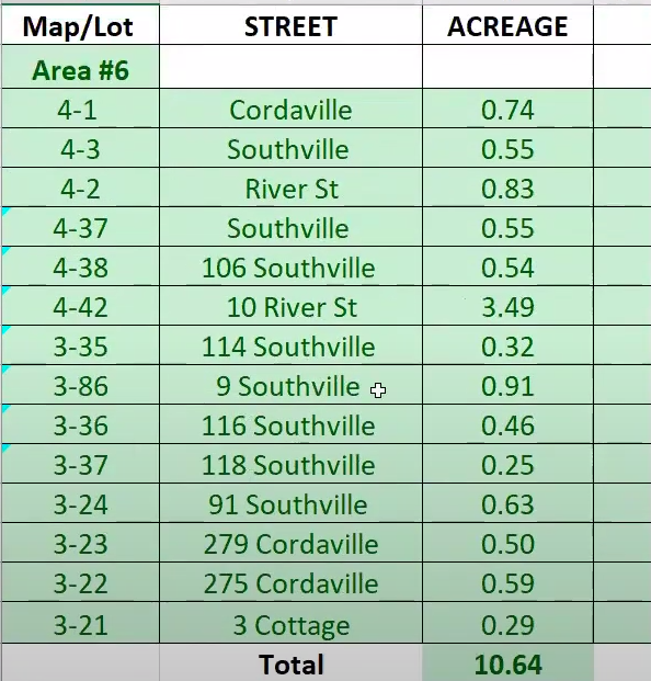
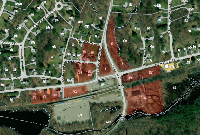
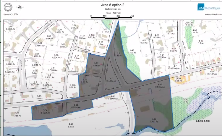 To meet the requirement for 10 acres within a 1/2 mile of the station, the board selected 10.64 acres right by the Commuter Rail Station (see image right). The proximity is consistent with the state law’s intent to create more housing opportunities near mass transit.
The area does abut a number of residential homes, but is sited on busy roads rather than quiet back streets. (It appears to include a triangle owned by the Town and another parcel owned by the state, so I am curious as to how that can pass muster with the state.)
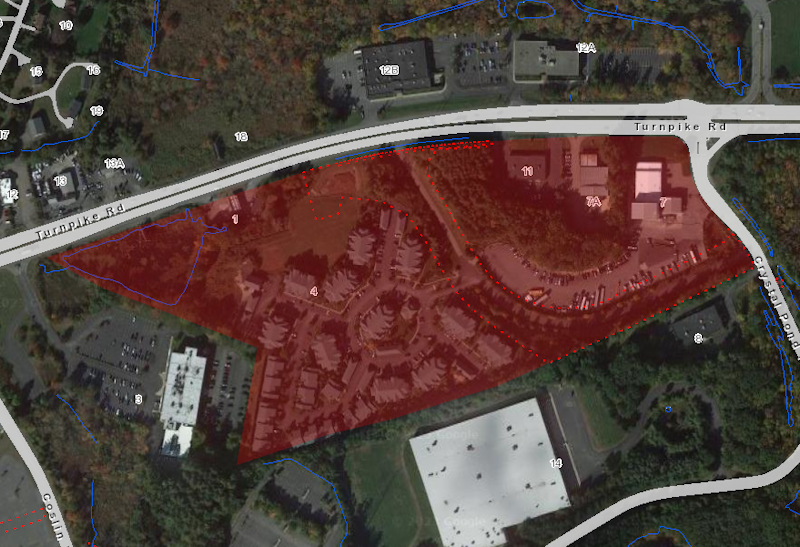
Click on images below for the list of the 14 property addresses included and more views of the area.
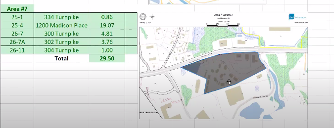
“Area 7” with Madison Place
The Town was also required to create a parcel that covered at least 25 contiguous acres.
This 29.5 acre area at Route 9 and Crystal Pond Road is focused around a parcel that is already the site of denser housing — the Madison Place apartment complex (created as a 40B development). It also includes a few abutting commercial properties.
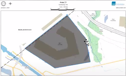
“Area 21” – 34 St. Martin Drive
Finally, the Town needed to come up with a total of 50 acres, with no district smaller than 5 acres. To make up the remaining acreage needed, they selected a 14.59 acre commercial parcel owned by Marlborough Technology Partner. Stansfield noted that you can’t access the parcel directly from Southborough. But she said that Bohler told them that wasn’t an issue with the guidelines, nor is the fact that it is a single parcel.
“Backup” contingencies
The following properties would only be proposed as districts if the board learns that the first three don’t suffice. (Scroll down for more on that.)
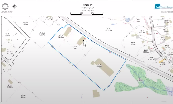 The first backup is “Area 14”, is 9.52 acres of abutting commercial properties on Boston Road (175, 179, and 185).
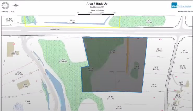 The second, listed as Area 7 Backup, is a bit east of the Madison Place district. It is 9.52 acres of mostly trees on Route 9. A large section is identified on the map as wetlands. It consists of three parcels owned by Old Iron LLC.
Next Steps
Based on Bohler’s advice and preliminary data, the board is hopeful that three parcels they selected will fulfill the state’s requirements. However, Bohler needs a week or two to finish inputting all of the details into the compliance model to fully vet them. If problems come up, the board may need to make tweaks or look at including one of the backup districts.
Bohler is also working on language for the zoning bylaw to be used in an Article for Annual Town Meeting at the end of March.
Leading up to the meeting, Planning will hold public hearings on the bylaw and zoning map. Through that process, they will hear public feedback and potentially make changes. The hearings will open on the evening of Monday, January 29th.
Updated (1/10/24 4:27 pm): I forgot to mention, Chair Meme Luttrell confirmed that the board plans to include a 10% Affordable Housing requirement, the maximum allowed under the state law. (Technically, the Town could pursue 20%, however that would require proving to the state that projects would still be economically feasible for developers.)

Many towns in the Commonwealth are fighting this state edict which many believe goes against the rights of Towns and Cities to control their own zoning and planning rules. This will be making it to court and the courts will have to decide if this state rule/law is legal or is an overreach by the state into the powers of towns and cities.
I think it is fine to review and plan what projects and areas may work for changes in zoning if the MBTA ruling is found legal. If it is not found to be binding than the town can continue to Zone and plan as they have for hundreds of years.
My personal feeling is that some areas should be available for thoughtful multifamily housing and commercial office and retail space if the neighbors welcome it. If it is not wanted than it should not happen or be forced onto neighborhoods.
Caveats first: I’m not a lawyer, and though I think the law ought to be intelligible to normal people, it often isn’t.
Massachusetts is not a federation of municipalities. The state grants powers to the cities and towns through their charters and home rule petitions, and it can take them away as long as it doesn’t single out any particular city or town. (See Section 8 of https://malegislature.gov/Laws/Constitution#amendmentArticleLXXXIX.) I think the MBTA Communities Act, passed by the legislature and signed into law by then-Gov. Baker is undoubtedly constitutional, and any town trying to delay it is only trying to use delay as its primary legal tactic.
The Commonwealth has been quite gentle in enforcing this Act, allowing all sorts of flexibility to towns to do transit-related zoning. Massachusetts knows we have a long-standing housing shortage and wants to turn the profit motive loose to help. Zoning, of course, restricts private property rights, and our government has decided that much zoning restricts them too much – and I agree. It really is a good idea to put denser housing near public transit. (And, yes, the MBTA needs work, too.)
We out in the suburbs have a long history of NIMBY, and it’s not just us, since cities do, too. NIMBY is sometimes right. The classic zoning example is that no one wants a pig farm next to their house. But the principle can’t be that the neighborhood can always say no, and a three-family next to Residence A or B isn’t a pig farm. I realize that people (not just other people, often me too) don’t like change, but this is a change that we as a community and as a commonwealth need.
And, by the way, zoning is only about a century old, which is to say only a few decades older than I am. Before that, it was possible to put a pig farm next to a neighborhood.
Also, Jack, I was recently walking in the Rural Cemetery and saw your headstone. I was pleased that it didn’t have a death date on it!
I agree with you on a lot of your points. I disagree with the idea that the state has been reasonably flexible with towns.
15 units per acre is quite dense. It does make sense to have opportunities like that near the MBTA But as Southborough complained, 50 acres of that within half mile of the train station did not make sense. The compromise was to allow 40 of those acres to be beyond the half mile, but the density is the same.
I completely agree that having a 2 to 3 family house next to yours doesn’t ruin your neighborhood. But if MBTA zoning was put in a neighborhood where lots are about a third of an acre, that would allow a five family home on one lot and if two pieced, together, 10 units by right. (Apparently, the density could be lowered, but it would require increasing density in other sections of the map.)
Because of the fear of large complex being built on their street, obviously residents would oppose zones that in a neighborhood.
That led to the planning board seeking out parcels that wouldn’t disturb neighborhoods.
But because there are vacant/underused commercial parcels where it is clear that the zoning would be very attractive to have something quickly built, some select board and advisory members stated concerns that zoning would lead to a sudden surge of new housing that would have a negative impact on the town’s financial burden.
So planning also appeared to seek out parcels that are unlikely to be converted for the purpose anytime soon. I think that means it has a chance of passing at Town Meeting, but don’t believe it will lead to the impact the state was hoping for.
I personally would be in favor of more zoning that allows accessory apartments and duplexes by right and 3 to 4 family homes by special permit.
I also wouldn’t be against zoning that allowed more mixed use on route nine, something the EDC is advocating.
I believe the law is well intentioned. But I believe the regulation and approach is not the right solution.