

Above: At the same time as it seeks relief from the state, the Planning Board is heading back to the drawing board for mapping an MBTA zoning overlay area within a ½ mile of the train station. (image from Town website)
In March, the Planning Board scrapped plans to ask Annual Town Meeting to MBTA zoning to allow denser housing in three areas of town. They are now taking a multi-pronged approach to trying to comply with state laws. That includes soliciting public feedback as they try to outline a new map by June 23rd.
At the same time, they are also asking the state to make some concessions.
[Editor’s Note: For those who haven’t been following this topic — MBTA zoning is a state requirement for the Town to pass zoning changes for 50 acres in town that would allow by up to 15 units of housing per acre without a special permit. You can read more in my past coverage.]
Re-engaging public feedback on one area of Town
On the evening of Monday, June 3rd, the Planning Board will hold an in-person mapping session. They will again be seeking public input on which parcels to include/exclude in a potential zoning overlay. (Stay tuned for event details.)
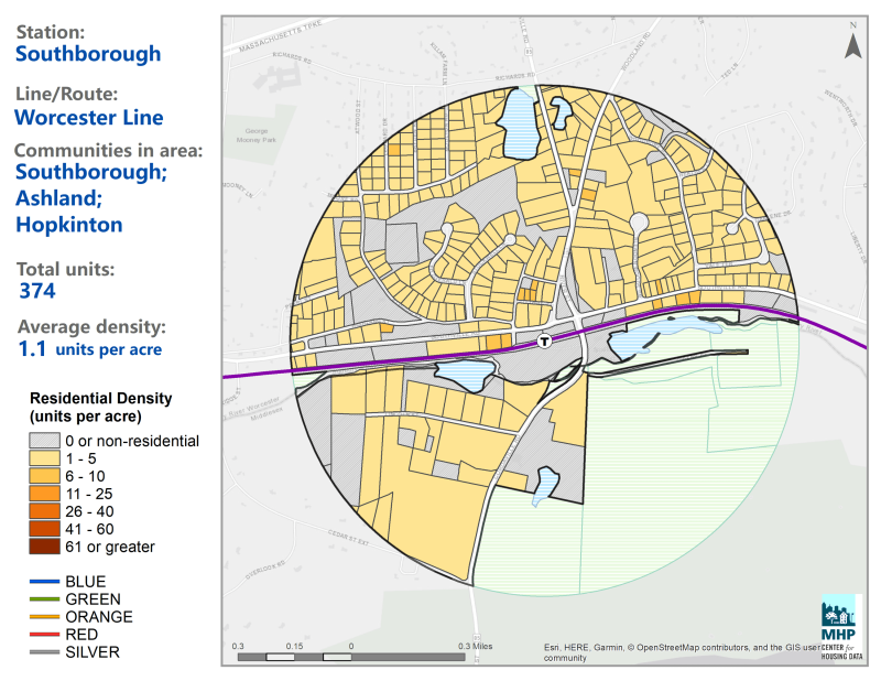 The session will specifically focus on revisiting the ½ mile area around the train station. (By then that circle may be shifted or extended a little further east.) The session will be open to any residents, but they will specifically solicit feedback from residents within that section of town.
Given the short timeframe for meeting deadlines, the board came to a consensus this week that it won’t pursue potential changes to the other two maps they identified in other areas of town. If the state extends the compliance deadline, then they will consider revisiting them. (You can see those other areas in a past post here – #21 & #7.)
This past Monday, the Planning Board focused on the zoning issues for over two hours in a zoom meeting that train station area residents were invited by letter to participate in. They provided an update, solicited public feedback, answered questions, and discussed next steps.
Board isn’t Trying to Defy the State
At this week’s meeting (and in other forums) I heard questions about why the board isn’t fighting against the state law. The board noted that 77 communities have already passed MBTA zoning and only a handful had fought it, with the success of their efforts unknown.
Member Marnie Hoolahan pointed out that the first test case isn’t scheduled for court until this fall. In the meantime, the board believes it is in the Town’s best interest to demonstrate that they are attempting to comply, while also urging for some relief. (See section below.)
Hoolahan stressed that the board will come up with its best recommendation to bring to a Town Meeting, but it will be up to voters whether or not to approve the zoning. She urged voters to stay informed and engaged.
In answer to a questions from resident Bruce Sturgeon about engaging state representatives to fight for us, Planning member Jesse Stein said he had reached out to our State Senator Jamie Eldridge (who was on the committee that passed the law) and never heard back.
Chair Meme Luttrell quipped that she believed our state reps were “all in” on the zoning legislation.
Pushing for Changes to Schedule and Requirements
On April 30th, the Select Board and Planning Board issued a joint letter to the state on their “Urgent Request for Assistance Regarding MBTA Communities Mandatory Law Compliance”. The boards assured that the Town is seeking to meet its legal obligations but needs some relief based on obstacles.
The boards asked for a deadline extension since the Planning Board’s schedule was derailed based on errors by the state-approved consultant that had been provided for assistance. (In March, they learned that a map they had been told was compliant didn’t actually meet the standards for that section of town.)
They also asked for relief from the required amount of compliant zoning mandated within a ½ mile of the station. Currently, the state is asking for zoning that would allow 150 acres to be built on 10 acres (that can be split to two parcels of 5 contiguous acres). The letter stresses that it is currently the more affordable area of town, with many historic homes, and includes a large riverfront wetland area with conservation restraints.
The letter was sent to the Executive Office of Housing and Livable Communities (EOHLC).
On Monday night, the public heard a recap of a follow up meeting with EOHLC’s Director of the Community Services Division, Chris Kluchman. In it Luttrell and Planning staff raised additional questions not covered by the letter.
Lutrell provided examples to Kluchman where the Town and state GIS maps list parcels as larger than indicated in the Compliance Model* that was supposedly based on the same data. She said that has been negatively skewing some of the compliance calculations. (She indicated the differences were small but can add up.)
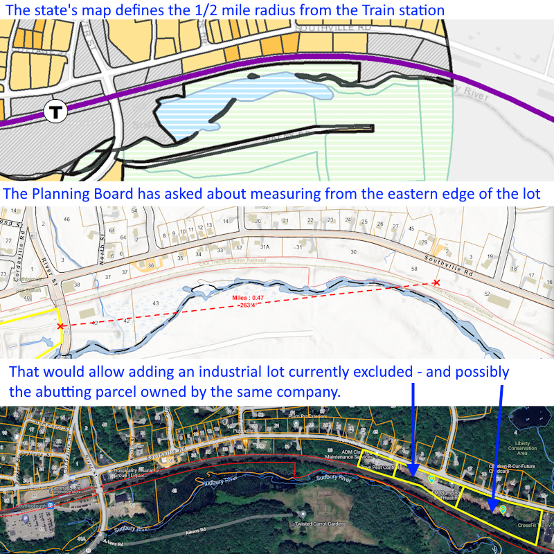 They also asked to shift the radius for the ½ mile around the T-station to be measured from the Eastern border of the lot.
At their April 29th meeting, the board had demonstrated to the public that if the radius was drawn further east, they could include 3 industrial parcels. Luttrell explained that while the easternmost parcels would be outside of the circle, since it has the same owners as the abutting parcel, she believed doctrine of merger would allow its inclusion. (See image above right for my visual explanation.) This week, they updated that Kluchman promised to check on that and their other questions and get back to them.
Luttrell also shared that Kluchman expressed surprise about the issues they had with the consultant (Bohler Engineering). The Director had been under the impression that consultants would play with the models to come up with a variety of options for the towns. Luttrell described that their support had been much more limited.
Mixed Use Debate
In Monday’s meeting, the board discussed the idea of adding Mixed Use zoning to the MBTA Zoning maps. That could require buildings’ first floors to be used for specific commercial/retail uses. They wanted public feedback from residents near the train station.
Commenters generally agreed with resident Phaea Cready who opposed mixed use with tire shops on the first floor. The allowance of bakeries, coffee shops, or cafes was less frightening, or even attractive, to some commenters. But some were outright opposed to any mixed use.
Resident Anne Deschamps opposed the concept of the types of buildings it could add to their neighborhood. She stressed that it was very different from the image they were initially presented of “cute little multifamily houses”. Others worried that given the high commercial vacancy rate in their area, it would just lead to empty ground floors.
At this stage, the Planning Board’s consensus was that mixed use would add too much complication to their efforts without clear enough benefit.
Resident Ben Cohen pushed back, arguing the need to be more comprehensive in their thinking and planning for potential future development. He worried that adding dense residences without businesses they can walk to support their needs would cause more traffic issues.
Commenter Freddie Gillespie disagreed. She pointed to the areas the board has been eyeing for potential overlays as lacking the sidewalks and having cars that travel at high speeds. She followed that the riverfront biome prevents sidewalks from being added.
Commenter Andrew Pfaff (who lives outside of the ½ mile and happens to be the Advisory Committee Chair) explained that wants Mixed Use included for fiscal reasons. He argued that if dense residential zoning is passed for areas currently zoned as commercial/industrial, property owners will pursue the more profitable option. That would mean that Southborough would lose more of its commercial tax base, increasing the burden on residential taxes. Passing underlying Mixed Use zoning requirements would help mitigate that.
Planning’s Current Timeline
(Obviously, if the state extends the deadline by enough time to make a difference, the below timeline will change.)
The current state deadline is December 31st. The board is shooting for a Special Town Meeting in early fall, on September 23rd. That would allow them time to pursue changes and hold a second fall meeting if voters reject it in September. (In prior Select Board meetings, it was discussed that the Presidential election and early voting also impact the Town Clerk’s ability to hold Town Meetings in the fall.)
The state has told towns to give them 90 days to report back whether proposed maps would meet regulations. Therefore, the board is looking to finalize maps for submission by June 23rd. That means agreeing on a map within twenty days of the June 3rd re-mapping session.
Commenter Paul Carter, who wants the board to comply with the legal intent of the law to aid the housing crisis. He forecast that those who oppose zoning changes will turn out to a Special Town Meeting while many other voters won’t bother to attend. He advocated that the meeting include items of interest to other voters.
Confusion and Communications Issues
Hoolahan urged residents to read up on the Town’s zoning efforts and come to meetings informed. Some commenters made clear that they were trying to, but having trouble finding information or understanding all of the details.
The board discussed the need to update its web page to make it easier for residents to follow the latest status. Hoolihan said she would work on a new deck of slides to use.
Meanwhile, a debate at the meeting between the Planning Chair and staff about one requirement demonstrated how the complex regulations complicate efforts to educate the public.
The board discussed the potential of mapping more than 10 acres within the ½ mile circle in order to meet the minimum potential of 150 units. Business Admin Colleen Stansfield said her understanding was that a larger area would increase the number of units they need to zone for under the regulations. (I believe she was referring to the density ratio requirements they would need to meet.) Lutrell argued that was incorrect.
In the end, it was agreed that they would get clarification and report that at their next meeting on May 20th.
Neighbors’ Status Update
In the public meetings, residents often raise questions about neighboring towns. So, here’s an update on their efforts.
Last night, Hopkinton rejected its Town’s zoning effort at their Town Meeting. According to the Hopkinton Independent, “Following about 40 minutes of debate during the third and final day of Town Meeting at the Hopkinton Middle School auditorium, Article 39 failed by eight votes, with 118 in favor and 126 opposed.”
In contrast, this spring, both Northborough and Westborough approved their zoning overlays. Like Southborough, Ashland’s Planning Board delayed its proposal to a fall Town Meeting.
Framingham and Marlborough don’t have to worry about Town Meeting schedules since the approval authority lies with City Councils. Framingham has just started public presentations on the zoning requirements and has yet to even hold a public hearing on a potential area. (Marlborough had proposed and debated a potential map last spring but I couldn’t find a current status.)
*The Compliance Model is a digital tool created by the state for use by towns and their consultants. Users can enter the parcels that a town would include in an MBTA zoning overlay district, along with the current underlying zoning regulations (including height and setback restrictions). They should then get calculated results for how fully those areas would comply with the mandated minimum requirements for the potential number of units that could be built.

I don’t know why any residents would waste their time attending yet another public meeting proposed by this Planning Board. It is clear that last time all previous public input was just simply disregarded, and the PB came up with their own little plan, which after much denial on their part, was found to be illegal. It seems to have occurred to no one on this board to ask the basic first question: if we comply with this unfunded mandate (which may in itself prove to be unlawful) what are the ramifications? Oh dear, will we lose 40K in state funding? Or heavens, be sued, again? Do we close a school as planned, or are we stuck building two $75M new ones? What happens to tax rates, services, our seniors? Will our population increase by 25%? Will our largely empty 20M Palace of Police finally be filled? What are the traffic implications, and the environmental impact? And why, oh why is this board fighting several viable affordable housing solutions along Rt 9 if you really care about affordable housing? Forget about wasting more time on another futile plan: start PLANNING, planning board, and clearly map for us the consequences of all this before descending into the weeds so we the ratepayers can logically decide our future for ourselves!!