
As the Select Board and a Working Group prepare to ask Town Meeting voters to approve moving forward with a controversial park, questions continue about what the state was led to believe when approving the related grant.
I’m sharing an update on the latest developments — and providing more context on questions publicly raised about the former DPW Superintendent’s communications with MassDOT.
Public Questions About What the State Was Told
Earlier this month, I wrote about residents’ questions about whether any Town officials misled MassDOT about the ownership of property that infrastructure grant funds would be spent on improving.
Since then, an email was brought to my attention that has shed more light on the concerns.
Records show that before the “Shared Streets” grant was awarded, a grant coordinator sought clarity on ownership of the parcels involved in the project. The answers provided by the former DPW Superintendent (including an incorrectly labeled map) were in the best light confusing, and in the worst light misleading.
Scroll down for those communication details. First, I’m sharing some updates on what is currently happening with the project.
Park Design Progress
In tonight’s meeting of the Working Group, they will hear three 5-10 minute presentations on potential designs. Then the group will discuss and potentially vote on elements that they would like to see in the design. The hope is to come up with a concept, even if rough, that can be presented to Town Meeting voters on March 25th.
Proposed Land Swap Agreement Revisions and Questions
Last Tuesday, the Select Board discussed a revised version of the “MOU” they plan to sign before Town Meeting. Unlike the earlier draft, it specifies that construction of the project is contingent on Town Meeting approval to swap ownership of the school’s and Town’s parcels.
It also states that in the case of the swap being rejected by voters, the Town will have legal access to the school’s property only to clean up the mess:
the Town shall retain a license to enter on the School Property and complete any grading or landscaping restoration activities as the parties may agree is necessary with respect to previously work done by the Town.
Worrying that “license” is a hot button issue, the Board discussed further changing the language to simply clarify the right (and fix a typo elsewhere).
Upon questioning, the Board explained a confusing section specifying that if parcels are successfully swapped, the Town will pay for work on the “School Property” and vice versa. The document legally defines the parcels by those names on page 1. Therefore the clause confirms that the Town would not pay for work on the parking lot and old section of road, just on the new road and park.
Board members were themselves confused by another section of the agreement. They will ask Town Council to clarify why it specifies their rights to construct the project once Town land after “conveyances”.
They aren’t the only ones seeking clarity and potential revisions. The Select Board agreed that the Planning Board should be given time to work out with Counsel concerns they raised in their meeting the night prior.
Planning members were disconcerted by a clause that seemed to allow the project to potentially bypass approval for Major Site Plan application. They were also worried that it might allow the land swap to be nullified if the school is unhappy with the Site Plan decision/conditions, but still somehow allow the project to proceed. They have asked Counsel to attend their next meeting on February 27th.
The Select Board is striving to have a version that passes muster with both boards and the School to be approved at their February 28th. They will then need the school to approve the agreement in time for Town Meeting.
Road “Discontinuance” and Engineering Explanation
One of the Articles headed to Town Meeting on the park project is the discontinuance of the current intersection. The Planning Board is charged with making a report on the Select Board’s request to Town Meeting.
This is another topic Planning wants Town Counsel to answer questions on in two weeks. Given the history of the road and how past changes were handled, they were uncertain about the legally defined right of way and how it would be discontinued.
During their discussion, VHB consultant Greg Russell answered questions that addressed some public accusations that the project was prompted by the private school wanting a bigger parking lot and not for the benefit of the Town.
Russell was asked to recap the genesis of the overall project. He explained that the project wasn’t simply to relieve flooding at the intersection or the turning radius for emergency vehicles. The firm had been asked to come up with something to solve those issues, address flooding issues at the Southborough Library, and add a sidewalk that was part of a Town plan.
The project was VHB’s best overall solution. Then the grant “offered an opportunity to build it”.
Asked about the Library’s past flooding problems, he explained that water came into the driveways from the roads plus in “sheets” off the abutting land. The land problems were is due to the elevated “crown” of the triangle. Both the Main Street Reconstruction Project and this project in took into account the studies the Library previously had commissioned on the water issues.
Later in the meeting, the Board learned that the Town Administrator recently emailed the interim DPW Superintendent to ask him to get the ball rolling on applications to their board related to public shade trees and a stonewall on St. Mark’s Street that were removed from project area without a Planning Board hearing.
Member Marnie Houlihan pointedly asked for a reminder of when the Board’s letter to the Select Board on the road and tree issue was sent. The answer was September 12th.
What was MassDOT Told and When?
The following communications are from a public records request and a timeline previously publicly shared that was created by Vice Chair Chelsea Malinowski.
On January 7th Cassandra Gascon of MassDOT emailed DPW Superintendent Karen Galligan before the grant was approved to seek clarification about land ownership:
I work for MassDOT as a part of the Shared Streets and Spaces Grant Program team. I had a question about Southborough’s application: it seems you answered ‘No’ to whether the proposed project is entirely on municipal property. Can you provide more detail on this? What parts of the project are and are not on municipal land? For the parts that are not, has formal permission or permits for its use been obtained already?
Any information you can provide related to this would be very helpful.
The next day, Galligan responded by providing the map that circled the park area next to the Library and the corner of St. Mark’s field on Main Street, noting they were “subject to license agreement with St. Mark’s School for Public Use”.
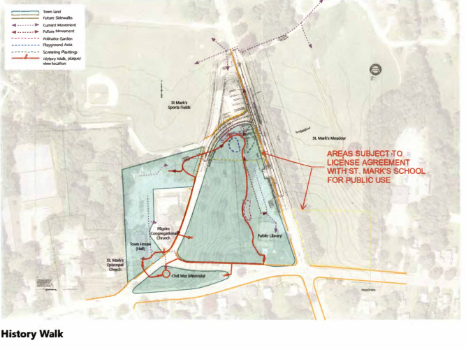 The incorrect key on the map indicates that the park area is owned by the Town – which would mean that the only St Mark’s land involved is St. Mark’s Field. The message with it stated:
Thank you for calling me. Attached is a schematic plan that breaks out the land ownership of the proposed project work. The piece of St. Mark’s Field on the east side of Route 85 is really not part of the proposed work. Basically, there are some sidewalks and the gathering areas proposed on St. Mark’s land.
Also, I spoke to St. Mark’s this afternoon and the Head of School is in the process of putting together a permission letter for using the land for the gathering areas and sidewalks. They are planning on having that to me early next week.
In subsequent emails to St. Mark’s, Galligan states she didn’t know why the field was highlighted on the map. No mention is made of the incorrect key.
After her reply to Gascon, she emailed St. Mark’s CFO Robert Kuklewicz:
Here is the plan I sent to the State – I told them that the section of St. Mark’s Field east of Route 85 is not part of the proposed project.
We put the project grant request in for $280,000, which included sidewalks and gathering areas
On the 9th, Kuklewicz responded:
I did have one question. Could you describe the second yellow dashed-line area on our main field on the East side of Rt. 85 at the corner of Main?
Galligan replied:
That piece isn’t really anything. They put it on as a place for movies, food trucks etc.., but it is an area that you already let the town use and that we don’t need to do anything to use. So I’m not sure why it is there”
The school then followed up with a January 18th letter (included in the timeline) for submission to the state in support of the project. It assured of the school’s interest in supporting the project by offering use of its “parcel” (singular), and didn’t include clarification of the location:
I am writing to confirm our support for the Town of Southborough’s plans for a series of new sidewalks, pedestrian connections and gathering spaces to develop the “Southborough History Walk”. We are excited about the prospect of the enhancements and the many benefits they would offer to residents of Southborough.
We are committed to offering the use of the necessary parcel of St. Mark’s School land needed to complete the plan.
Officials have used a much later email exchange I previously shared as dispelling any allegations of wrong doing. But they don’t clarify what MassDOT officials knew that at the time the grant was awarded or if they understood that work on the project began before the promised license agreements were signed.
Messages between Town Administrator and a MassDOT employee confirm that as of a meeting on June 1st, the state was aware that St. Mark’s School owned part of the land involved and accepted the use of license agreements.
The meeting was prompted by a request from the Inspector General’s office following up on complaints from the public about how the state funds were used.
The messages confirmed the meeting held to discuss the Town’s Shared Streets grant award for the St. Mark’s Street park project. The meeting included Town Administrator Mark Purple, Galligan, Gascone and other MassDOT officials.
On September 12th, MassDOT District Highway Director Barry J. Lion confirmed that “District 3” had “general agreement” with the following facts as summed up by Purple:
- MassDOT was asked by the Inspector General’s Office to review the St. Mark’s Street project expenditures under the Shared Streets grant based on complaints it received or were made aware of through their process;
- In reviewing the grant expenditures for the St. Mark’s Street project, MassDOT has determined, and Cassandra concurs, that the funds were spent appropriately on those items related to the grant as defined in the application;
- Other road funds, including Chapter 90, were spent appropriately on the project as discussed; While the cross country path of the History Walk wasn’t constructed, the DOT understands that the park, and it’s associated sidewalks and walkways, serve as the final connection of the loop of the sidewalks on Marlborough Road, the existing Library Walkways, the Sidewalks on Common Street and the Town House lot;
- Although the lack of a “history walk” in the actual project may have made the project less attractive in the grant review process, the project was still viable for consideration of a Shared Streets grant; however, the DOT sees that the cross country portion of the History Walk is the only missing piece and was not the main piece of the History Walk;
- Mass DOT will await notification from Southborough that the park area has been completed so that they may come out to inspect the final product. It was understood that the work had been paused so that St. Mark’s School could undertake an archeological study of the proposed park area, based on concerns raised by residents;
- Should the park not be completed, then another conversation about the Shared Streets funding will need to take place, as the construction of a park was a condition of the grant award;
- Until the park is completed, future grant applications from Southborough will be paused.
Lorion added:
we also discussed property ownership and wanted to ensure the work was done on property that was in the public domain.
Purple further clarified:
We did discuss the reciprocal license between the Town and St. Mark’s School for the work on the properties that were owned by St. Mark’s, and I believe that everyone was in agreement that this was acceptable for the project. As an aside, the Board is continuing to explore the possibility of an acquisition of St. Mark’s land for this project, rather than replacing the license with an easement.
Lorion confirmed that they were fine with the license agreement.
