
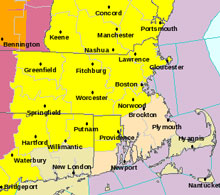
In case you haven’t heard, the National Weather Service has issued a tornado watch for most of Massachusetts, including Worcester County (that’s us, folks). A watch doesn’t mean any tornadoes have been spotted, just that conditions will be right for tornadoes, large hail (2” or greater), and/or straight-line thunderstorm winds, and frequent cloud-to-ground lightning. Sounds like a fun afternoon.
According to the NWS, a cold front approaching from New York state this afternoon may generate some potentially severe thunderstorms. The storms will reach southwest New Hampshire and western Mass by 1:00 to 2:00 pm, the then push eastward through the rest of the afternoon. They’re expected to reach the Boston to Providence corridor by 4:00 to 5:00 pm. Just in time for the commute.
Damaging winds and large hail is possible. A severe thunderstorm that passed just north of us this morning — close enough to hear the rumbling — is being blamed for a house fire in Andover.
The tornado watch is in effect until 8:00 pm today.
Update 5:12 pm: If you’re watching local news, you already know there have been several reports of tornadoes on the ground in western Mass, and the alert for Worcester and Middlesex counties has been upgraded to a tornado warning. The area under the warning INCLUDES SOUTHBOROUGH (sorry to shout). Please use caution and get to a safe place if you’re not already there.
(Image: National Weather Service)
